SANTA RITA ROAD
Santa Rita Hills AVA
Santa Barbara County, California
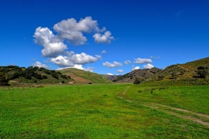
Ripe with potential for the development of premium vineyards in the Santa Rita Hills AVA, this ~383 acres has ~170 plant-able acres.
An internationally acclaimed viticulture region, the reputation of the Santa Rita Hills is built upon its unique climate.
The region is an east-west corridor to the Pacific Ocean cooled by the influences of ocean breezes and early morning marine fog.
The region grows worldwide known Pinot Noir, Chardonnay and Syrah.
This property, because of its predominately south-to-north orientation, is protected from the stiff winds that tend to reduce yields in the more exposed areas of this AVA. The combination of the cooling ocean climate with the wind protection afforded by hillsides along the western edge of the property creates a climate for vineyards of premium quality wine grapes that, in addition, will produce high yield crops.
The terroir is composed of a combination of well drained open valleys, mesa hill tops and slopes, including south facing.
Elevations range from about 500 to about 1000 feet.The soil types vary; primarily composed of sand and loam types.
Subtle variations in climate, slope, soils and sun exposure will potentially produce the highest quality wine grape varietals.
The well was tested in 2014 with a production of about 600 GPM.
LOCATION:
2300 Santa Rita Road • Santa Barbara County, California
Santa Rita Hills AVA
ACCESS:
On an easement off of Campbell Road. About 9 miles from Buellton to the east and 7 miles from Lompoc to the west on HWY 246 in Santa Rita Hills AVA
ACREAGE:
~383 acres
ZONING:
AG100
PARCELS:
APN 099 – 110 – 002 ~40.37 acres - 2007- 70496 OR*
APN 099 – 110 – 011 ~40.09 acres - 2007-70499 OR*
APN 099 – 110 – 013, - 020 ~142.88 acres - 2007-82466 OR* - 2007-70497 OR*
APN 099 – 110 – 015 ~160.22 acres - 2007-70498 OR* - 2007-71920 OR*
*recorded Certificate of Compliance
IMPROVEMENTS:
WELL & WATER STORAGE: The steel magnesium 14” cased well was pump flow tested in 2014 at approximately 600 GPM
There is power (P.G.& E.) to the well site. The well is located at the southern end of APN 099 – 110 – 013
There is a reservoir at the north end of APN 099 – 110 – 013 and one to the north of the farm field on APN 099 – 110 – 015
HOUSE:
A 3 bedroom, 1 ¾ bath house on APN 099 – 110 – 011. There is currently no potable water to the house
INCLUDED MAPS** (via "More Info" button above):
Assessor’s Parcel and Certificate of Compliance Aerial Overlay
Assessor’s Parcel and Topographic Aerial Overlay
NRCS Soils Aerial Overlay
Aspect (Slope Direction) Aerial Overlay
Percent Slope Aerial Overlay
Projected Plant-able Areas Aerial Overlay
**Aerial mapping and overlays attached are approximate and are for general guidance only. All projections and lines are to be confirmed by a Buyer through independent investigations
All information provided is to be confirmed through a Buyer’s independent investigations and the Buyer’s hired experts and consultants